Monday, June 24, 2013

KHAJJIAR HIMACHAL PRADESH INDIA


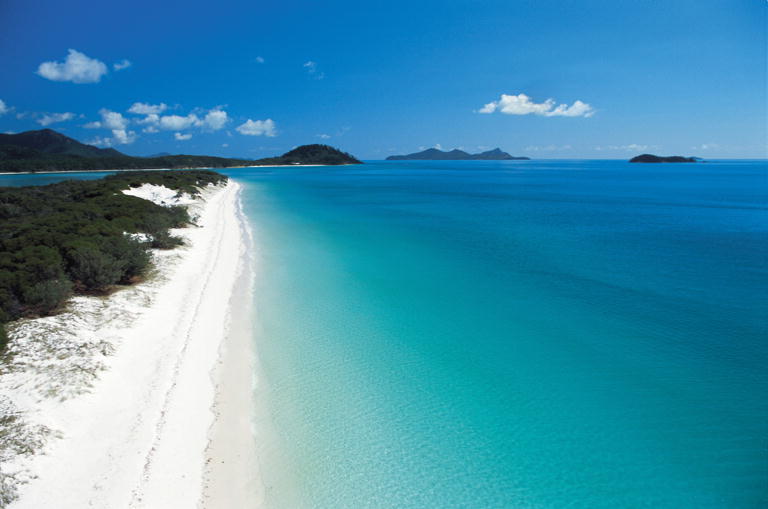
This beautiful place bears a very striking resemblance to switzerland’s topography, the well known romanticizing location. Khajjar is located at the foot of dhauladkar , in the lap of Himalayas and is 2000 metres above sea level. A beautiful panoramic view of the densely populated forests and the meadows and snowy peaks of Himalayas can be captured. Summer months are the best to visit this place as it wouldn’t be too cold and the hill station would be laden with beautiful flowers.


Khajjiar is often reffered to as "Gulmarg of Himachal Pradesh". The lush green meadows are surrounded by thick pine and cedar forests. Grazing herds of sheep, goats and other milch cattle present a prefect pastoral scenery. There is a small lake in the center of the saucer shaped meadow which has in it a floating island. Much of the lake has degenerated into slush because of heavy silting during rains. Still the landscape of Khajjiar is picturesque and a photographer's delight.


 A little away from the lake is the temple of Khajji Nag belonging to 12th C. AD. In the mandapa of the temple one can see the images of the Pandavas and the defeated Kaurvas hanging from the roof of the circumambulatory path. The sanctum of the temple has been beautifully carved from wood.
 There is a Tourism Hotel and some Tourism cottages at Khajjiar where the tourists can stay . Besides there are two rest houses one each of P.W.D. and Forest Deptt. A couple of private hotels have also come up, which do not match the above places in terms of location and amenities. Bus service to and from Khajjiar is limited and timings change according to local demands. There used to be a golf course in Khajjiar which is not maintained. The best entertainment in Khajjiar is to walk around the lake or to go for long walks in the thick pine forests. Children enjoy this place because of the freedom of movement and the slopy terrain which permits them to roll down to the lake without getting hurt. Another attraction like any other hill station is horse riding.

 On 07-07-1992, Mr. Willy t. Blazer, Vice Counselor and Head of Chancery of Switzerland in India brought Khajjiar on the world tourism map by christening it "Mini Switzerland". He also put a sign board of a yellow Swiss hiking footpath showing Khajjiar's distance from the Swiss capital Berne-6194 kms. Khajjiar is among the 160 locations in the world that bear topographical resemblance with Switzerland. The Counselor also took from Khajjiar a stone which will form part of a stone collage around the Swiss Parliament to remind the visitors of Khajjiar as Mini Switzerland of India.

Always remember, we link you to the world of realities, making your perfect dream a perfect past.


Monday, June 10, 2013

DUNES OF PYLA FRANCE


 One of those great places to behold on earth with a unique variance of the exact location is ; The Great Dune of Pyla ; located 60 km from Bordeaux in the Arcachon Bay area, France, happens to be the tallest sand dune in Europe. Also known as Great Dune of Pilat, the sand dune is enormous - measuring 500 meter in width, 3 km in length and rising to a height of 107 meter above sea level. Because of the dune’s unexpected location and beauty, it is a famous tourist destination with more than one million visitors per year.


Interestingly, the dune is relentlessly moving inwards, slowly pushing the forest back to cover houses, roads and even portions of the Atlantic Wall. The rate of movement is discontinuous; sometimes it moves fast (10 meter in a year) and sometimes very slow (less than a meter). During the last 57 years, the dune has moved some 280 meter giving an annual displacement of 4.9 meter per year.


This migration of the Great Dune has covered nearly twenty private properties, and each year the sand of the east slope of the dune covers 8000 square meter of the surrounding pine forest. At the North East part of the dune, a road was overlapped in 1987 after an avalanche of sand, and buried in 1991. An example of a house buried over the dune is cited in a newspaper in September 19, 1936. At the South East of the dune, a Bordeaux family had decided to have a villa built in 1928. Two years later, the sands began to invade the house and by 1936, the house had completely disappeared over the sands.


Maritime winds explain both that mobility and the shape of the dune; it offers soft slopes on the ocean side and an abrupt face on its east side, the forest side. For the most athletic visitors, climbing up this slope is a real challenge. For the others, a staircase makes the ascent a little easier. At the top, the view is spectacular – the sea coast, the vast pine forest of Les Landes and, when the whether is clear, the Pyrennees range

                                                               LOCATION ON THE MAP

Always remember, we link you to the world of realities, making your perfect dream a perfect past.


Saturday, June 8, 2013

WHITEHAVEN BEACH AUSTRALIA


One of those few places that reminds you of the very existence and power of nature, making you forget there exists a world of pain is the ; Whitehaven Beach ; a pristine beach on Whitsunday Island, the largest of the 74 islands in the Whitsundays. Whitehaven Beach stretches over six kilometers and boasts brilliant silica sand that is among the purest in the world. Sink your feet into the sand and wade into the warm waves that gently crash against the shore and you’ll soon realize why people come here from all over.

At the northern end of Whitehaven Beach is Hill Inlet, a stunning inlet where the tide shifts the sand and water to create a beautiful fusion of colors. Many people claim Hill Inlet and Whitehaven Beach are the most beautiful places they've ever seen.

There’s a lookout on Whitsunday Island where you can view both Whitehaven Beach and Hill Inlet. Most people moor their boats in Tongue Bay, take a dingy ashore and make the short walk to the lookout for the breathtaking views. If possible, try to reach the lookout when the tide is changing, as the golden sand and aqua water hues blend seamlessly into a mosaic of colors.


Whitehaven Beach can be experienced in several ways. If you’re interested in a day trip, there are ferries and luxury cruising yachts that depart from Airlie Beach. A variety of sailing companies also offer multi-day charters that include a memorable visit to Whitehaven Beach in addition to stops to the outer Great Barrier Reef.

Seaplanes and helicopters also visit the area offering stunning views from the sky. It’s even possible to completely indulge and partake in a romantic getaway to your own private beach for a champagne picnic.
Whitehaven Beach, it’s definitely a must-see in the Whitsundays.


                  LOCATION ON THE MAP

Always remember, we link you to the world of realities, making your perfect dream a perfect past.


Thursday, June 6, 2013

MANAROLA (CINQUE TERRE) ITALY


One of the most beautiful countries of the world and the Fashion craze strong power of europe; Italy, a home to the greatest number of UNESCO World Heritage Sites in the world. High art and monuments are to be found everywhere around the country. Its great cities of art, like Rome, Venice and Florence are world famous and have been attracting visitors for centuries. Besides its art treasures Italy also features beautiful coasts, alpine lakes and mountains. No wonder it is often nicknamed the Bel Paese (beautiful country).


The Cinque Terre are one of the most uncontaminated areas in the Mediterranean Sea. Five miles of rocky coast among two promontories, thousands of kilometres of dry-laid stone walls, five small towns castled up on stone spurs in minuscule creeks. For their history and their position, the Cinque Terre have not suffered a massive expansion. The vineyards, typical of this area, have contributed to create a unique landscape with dry-laid stone walls, winding paths, enchanting beaches between cliffs and clear waters.


                                                                 Location on the map


Not only sea, the Cinque Terre offer beautiful footpaths with take breathing view, churches, oratories and old castles, diving, food and wines of first quality.
The Cinque Terre are National Park and UNESCO protected territory since 1997. Riomaggiore, Corniglia, Manarola, Vernazza, Monterosso are the five villages that form the Cinque Terre, suspended between sea and land on sheer cliffs upon the beautiful sea.


Always remember, we link you to the world of realities, making your perfect dream a perfect past.

Wednesday, June 5, 2013

ROYAL PALACE MADRID


Just a little bit after the Royal Fortress burned down on Christmas Eve of 1734, King Philips V wanted to replace the fortress by a palace, this time built from limestone and granite to make it fireproof. It was to be modeled loosely on the Versailles Palace near PARIS, where Philips V had spent part of his youth.
Construction of the new palace started in 1938 based on a design by the Italian architect Juan Bautista Sachetti. 26 Years and three kings later, the huge palace, covering an area of 135,000m2, was completed. It would take another 100 years before completion.


Visitors enter the Palace via the large Plaza de la Armería. Some of the sumptuous rooms accessible to visitors are the 400m2 large dining room,
Inside the Royal Palace
the Sala de Porcelana (china room) and the Salón del Trono (throne room) with red velvet walls.
The west wing of the palace is home to the Arméria Real, the royal army museum. It contains a beautiful collection of armory, including King Charles V armour suit.


King Carlos III, son of King Philips V moved into the new palace in 1764. The Palacio Real would be the main residence of the Spanish kings until 1931, when king Alfonso XIII went into exile after republicans had won the elections and demanded him to step down.
Today the royal family lives in the small Zarzuela Palace, a former hunting lodge outside Madrid. The Royal Palace is still used for official ceremonies and receptions.
Right in the front of the Palace is Plaza de Oriente, a beautiful square with an equestrian statue of Philips IV. The Royal Palace originally bore the same name as the square, Palacio Oriente, or East Palace.
Statues of kings and queens are all over the square. The intention was to put these statues on top of the palace but they were deemed too heavy, so they were placed on the square in front of the palace instead.

Always remember, we link you to the world of realities, making your perfect dream a perfect past.

Monday, June 3, 2013

UNIVERSAL STUDIO JAPAN


Universal Studios is one of the most comprehensive entertainment enterprises in the world. The scale and diversity of its operations have made this entertainment giant a global leader in media and communications.
Universal Studios Japan™ opened in Osaka on March 31, 2001, initiating a new chapter in the 80-year history of this legendary entertainment company.


Universal Studios Theme Parks represent the excellence of the Universal brand. The Parks state-of the-art shows and attractions utilize the latest technology to place guests in the heart of the world of American motion pictures and television. Universal Studios Japan™ is the companys first movie studio theme park outside the United States. It is the newest addition to a growing family of first-class themed entertainment which includes outstanding parks in Hollywood and Florida.


Location: 2-1-3 Sakurajima Konohana-ku, Osaka-city 
Access: JR Yumesaki Line Universal City Station 
Park Hours: Check PARK OPERATION CALENDAR


There are many types of passes are available, including Studio Pass, 2-day Studio Pass, and more. Tickets can be purchased at JR ticket offices, Lawson convenience stores, official hotels, and so on

Always remember, we link you to the world of realities, making your perfect dream a perfect past.

NATIONAL MALL AND MEMORIAL PARK


One of those historical sites you can ever get any where in the world. The National Mall & Memorial Parks protects some of the older parkland in the National Park System. This premier park preserves some of the country’s most significant moments in history, providing visitors with ample opportunities to commemorate presidential legacies, honor the courage of war veterans, and celebrate the United States commitment to freedom and equality.


Information on how to get to this heritage palace.

For visitors driving into Washington, D.C., keep in mind that parking is limited and can get expensive. Public transportation is a great option. However, Interstate 395 provides access to the National Mall and Memorial Parks from the South. Interstate 495, New York Avenue, Rock Creek and Potomac Parkway, George Washington Memorial Parkway, and the Cabin John Parkway will all provide access from the North. Interstate 66, U.S. Routes 50 and 29 provide access from the West, while U.S. Routes 50, 1, and 4 provide access from the East.
If you really want to limit your carbon footprint, there are many major bicycle trails that flow through Washington, D.C. There are also several Metro train and bus routes from the suburban areas surrounding the city.
If you are flying in from out of town, there are three major airports that serve the area: Ronald Reagan Washington National Airport, Washington Dulles International Airport, and Baltimore/Washington International Thurgood Marshall Airport. All have limousine, taxi, or Metro services available that will connect with the National Mall and Memorial Parks.
Always remember, we link you to the world of realities, making your perfect dream a perfect past.